Bike Ride
Coyote Creek Trail
IBM SVL to Morgan Hill
Itinerary
The itinerary is not set in stone! It's just a rough idea of the timeframe involved. We can always change things on the fly if we're tired or want to play more :)
| Time | Description |
| 10:00am | Meet at IBM SVL parking lot |
| 10:30am | Latest time to start biking |
| 12:00pm | Arrive in Morgan Hill |
| 12:00-1:30pm | Eat lunch |
| 1:30pm | Bike to optional destinations if desired |
| 3:30pm | Latest time to start biking back from Morgan Hill to IBM SVL |
| 4:30pm | Arrive back at IBM SVL |
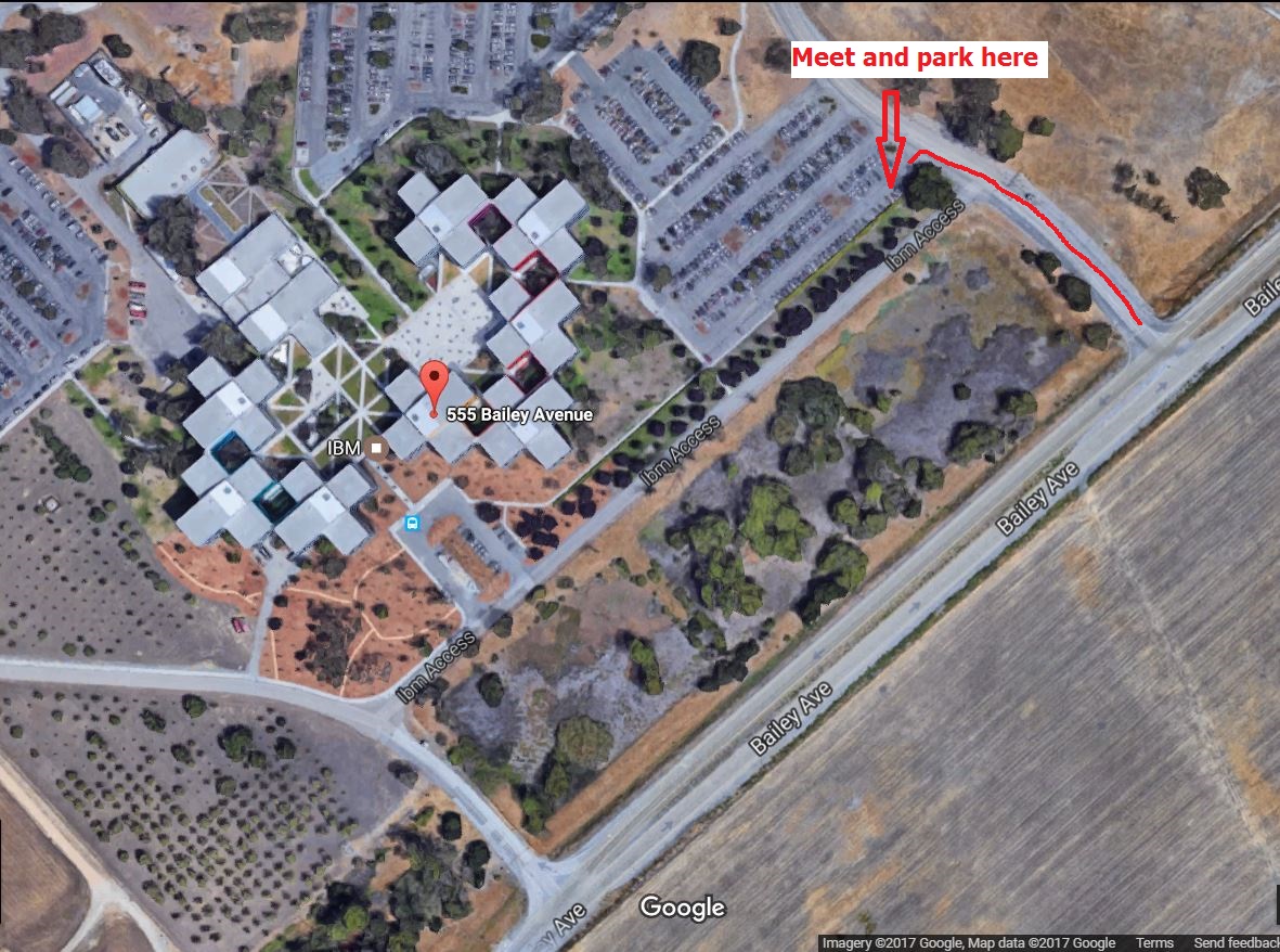
Meeting Location
We will meet inside the IBM Silicon Valley Laboratory (SVL) parking lot. To enter the IBM SVL parking lot, a badge is required. We'll park close to the gate and those of us who are IBMers can badge others in. If you are coming from 101 or Monterey Rd, turn right into the first entrance to the parking lot. If you are coming from McKean, turn left into the second entrance to the parking lot.
Use the following address and link to navigate via Google Maps:
555 Bailey Avenue, San Jose, CA 95130Picture showing the Coyote Creek Trail Head meeting place:
Biking Route
This biking route starts out at IBM Silicon Valley Lab parking lot, then out to Bailey and up the overpass, where there's an entrance to Coyote Creek Trail.
On Coyote Creek Trail, it's a pretty flat and nice relaxing ride. It doesn't have much shade, though. When we biked it in the winter, it was beautiful, sunny yet cool, with nice green grass and bushes. Most likely in the summer it'd be a hot and dry ride.
Coyote Creek Trail ends in Morgan Hill, close to Cochrane. From there, we can bike to various different restaurants for lunch. Check out the list of restaurants further below.
After lunch, if there's time we can do some other optional stops. Check out the list of optional destinations further below.
Given that there are multiple restaurant options in Morgan Hill and multiple optional destinations, I did not map a round trip route for every single possibility. Instead, I mapped a Google Maps route from the meeting location to Coyote Creek Visitor Center, right before the Coyote Creek Trail ends. After that, use the Google Maps links for the various lunch options or optional destinations in below sections to navigate.
- Google Maps: IBM SVL to Coyote Creek Visitor Center at Anderson Lake
- MapMyFitness: Bike Route (RT) IBM SVL to Morgan Hill (Odeum Restaurant)
- MapMyFitness: Bike Route (RT) IBM SVL to Morgan Hill (Ladera Grill)
- MapMyFitness: Bike Route (RT) IBM SVL to Morgan Hill (MOD Pizza & Anderson Lake Dam)