Camping at Stanislaus National Forest
Utica Reservoir
Itinerary
The itinerary is not set in stone! It's just a rough idea of the timeframe involved. We can always change things on the fly if we're tired or want to play more :)
| Friday Time | Description |
| 7:00am | Meet at Regina & Henry's house if you're carpooling with us |
| 7:30am | Latest time for departure from Henry & Regina's house |
| 9:00-9:30am | Meet at McDonald's in Stockton for breakfast |
| 12:30pm | Arrive at Utica Reservoir |
| 12:30pm | Eat lunch while en route in car (bring ready-to-eat food or buy to-go lunch from McDonald's or Burger King's) |
| 12:30-1:30pm | Hike to lake's edge and find a spot to camp |
| 1:30-2:00pm | Set up camp, gather firewood |
| 2:00pm onwards | Hang out by the lake, hike around, row on the lake if you want to bring a boat |
| Sunday Time | Description |
| 9:00am | Eat breakfast then pack up everything |
| 10:00am | Hike back to car |
| 10:30am | Leave Utica Reservoir |
| 12:00pm | Eat lunch somewhere in Angel's Camp, or bring food just in case we're late and eat at Utica or in the car |
Prep Ahead
If you have never gone camping or backpacking before, might want to go over a basic camping checklist:
Familiarize yourself with guidelines to keep the natural environment pristine:
Check the weather forecast at Utica Reservoir:
- National Weather Service: Lat: 38.468°NLon: 120.047°W
- Weather2: Utica Reservoir, Alpine
- WeatherForYou: Utica Reservoir, California, United States
Download driving directions ahead of time:
- Unless you have Verizon, all other cellular carriers have no signal once you pass Murphy on Hwy 4. From that point on, we need to use walkie-talkies to communicate between cars. We would normally meet up at the Ranger's Station and try to keep our cars close together the rest of the way up, but if we get our permits online, we might skip the Ranger's station.
- This also means that if you're relying on your cell phone for navigation to Utica Reservoir or to get the address of anything, you'll be out of luck unless you download offline maps onto your phone or download driving directions and addresses ahead of time.
Take the right car:
- The last section to Utica Reservoir is on unpaved gravel road. If you have a 4WD vehicle, we'd suggest driving that. We'd driven our 2WD Honda Odyssey before, but we had a hitch on it and ended up scraping bottom. The tires also ended up skidding trying to get up a slope, and we barely made it up. It's doable, but just be aware it might take some finagling to get the car up.
Prepare walkie talkies:
- It's especially better to have walkie-talkies if we're travelling in multiple cars/groups, or if you're wanting to arrive later than us. There are no cellular signals (other than spotty Verizon) in that area.
- Charge up your walkie talkies and set to Channel 9 Subcode 5.
Apply for and print out permit (updated 2022-04-02):
- We need fire permits for campfires or portable stove use, and also overnight wilderness permit if we plan to stay overnight in the wilderness. Each family should get their own permits. We can get a permit a couple different ways:
- The Calaveras Ranger Station is open again. We can stop here on the way to sync up, go to the restrooms, and apply for permits.
- Or you can apply online for a California Campfire Permit at the following site, print out the permit, and bring it with you to the campsite:
California Campfire Permit - Looks like there are currently no fire restrictions. If there are, then usually the restrictions prohibit wood fires or charcoal fires for dispersed camping and only stoves using liquid fuel are permitted:
Stanislaus National Forest Fire Restrictions
Camping Logistics
Taking 3 kids backpacking, we're going to keep things simple. Although it'd be more efficient to figure out who's bringing items that can be shared with the entire group, I'm too lazy to plan and coordinate, so everyone is responsible for bringing their own gear, food, and water. Or, you are welcome to coordinate on your own with others in the group :)
We plan on keeping food easy, i.e. Mountain House freeze-dried packages, instant noodles, maybe sausages to roast and eat with bread, and fruits. For water, we'll bring drinking water and a water filter to filter from the lake for cooking and washing. Don't worry if you can't pack water nicely. We can always make multiple trips to the car.
Going pee and poo means finding a place at least 200 feet away from the nearest water source, trail, or campsite. Then, dig a hole 6"-8" deep and 4"-6" wide. Pee or poop in the hole and use minimal toilet paper. Best is to pack the toilet paper back out in a ziploc bag, but you can also leave it in the hole. Cover the hole back with the original dirt and disguise with leaves, etc. For additional info on digging a cathole:
SectionHiker: How to Dig a Cathole
There is a lake there, so you're welcome to bring your own inflatable boat, oars, life vests. Last year, we brought a lot of stuff with us, and a new bigger size inflatable boat. We parked at the southern end of the reservoir, loaded up the boat, and Hubby and Oldest J rowed the boat and all the gear to the camping spot while the rest of us hiked. This way, we can actually bring a cooler and other heavier items :P
Since we're by the lake, there are plenty of mosquitoes. We've tried mosquito repeller lanterns, and they seem to work quite well at keeping the mosquitoes at bay. We'll also bring mosquito head nets and repellent spray. See Camping Checklist for more info.
At night, it gets quite cold. Be sure to bring a sleeping bag rated for the night time temperatures (check weather forecast). Sleeping mats/pads underneath help.
About Camping at Utica Reservoir
We'll be camping at Utica Reservoir, which is in Calaveras County, part of the Stanislaus National Forest. The elevation is fairly high (6,850 ft), so the air is crisp and fresh. The water in the reservoir is very clear and cold, and surrounded by many trees and boulders.
Although there are campgrounds at Utica Reservoir, we prefer to do dispersed camping rather than car camping. We'll park our cars off the road, and hike in a little bit (about .25 mile) to the lake's edge and pick a spot far away from other campers. There are no trails, and usually we have to climb over big boulders and pick our way across a small river. There are no facilities for water, no restrooms (not even porta-potties), etc. where we choose to camp. It's close enough to make multiple trips back to the car if necessary.
Non-motorized boats are allowed, so feel free to bring your canoe, kayak, inflatable boat, etc. There is a boat launch ramp, so another option which we've done before is to park at the boat launch area, load up gear into the boat, then row across the lake to the camping spot.
For more information, check out the following:
- USDA Forest Service: Stanislaus National Forest
- Calaveras Visitors Bureau: Utica Reservoir
- California's Best Camping: Union & Utica Reservoir Campgrounds
McDonald's Breakfast Location
We will meet at the following McDonald's in Stockton for breakfast, because it's conveniently located en route (Hwy 4). Note that right next door is a Burger King. McDonald's doesn't offer lunch food until 10:00 am, but Burger King does, so we can buy food from Burger King to eat as lunch later.
Use the following Google Maps link to navigate:
611 W. Charter Way, Stockton, CA 951206
Calaveras Ranger Station
We normally drop by the Calaveras Ranger Station right off of Highway 4 to obtain a campfire permit, sync up everyone in the group, go to the restrooms, etc.
Use the following Google Maps link to navigate:
5519 Highway 4, Hathaway Pines, California
Getting to Utica Reservoir
From Hwy 4, there are plenty of signs posted to indicate Utica Reservoir, so pay attention.
Directions from Hwy 4:
- Right onto Spicer Reservoir Rd
- Turns into Forest Route 7N01
- Left onto Forest Route 7N75
- Left onto Forest Route 7N17
This left turn is easy to miss so pay attention! The sign for Utica is very small under the bigger sign. Note that this is where the gravel route starts.
Following is a short video showing the turns on the forest routes to get to Utica Reservoir:
Rowing to the Campsite
The E's family started this trend, haha. They bought a bigger inflatable boat, stopped at the southern end of Utica Reservoir where there's a boat launch area, dumped all the heavy bulky items into the boat, and Dad/Oldest E rowed to the campsite while Mom/Youngest E hiked to the campsite. The following year, we also upgraded to a bigger inflatable boat and did the same thing :D
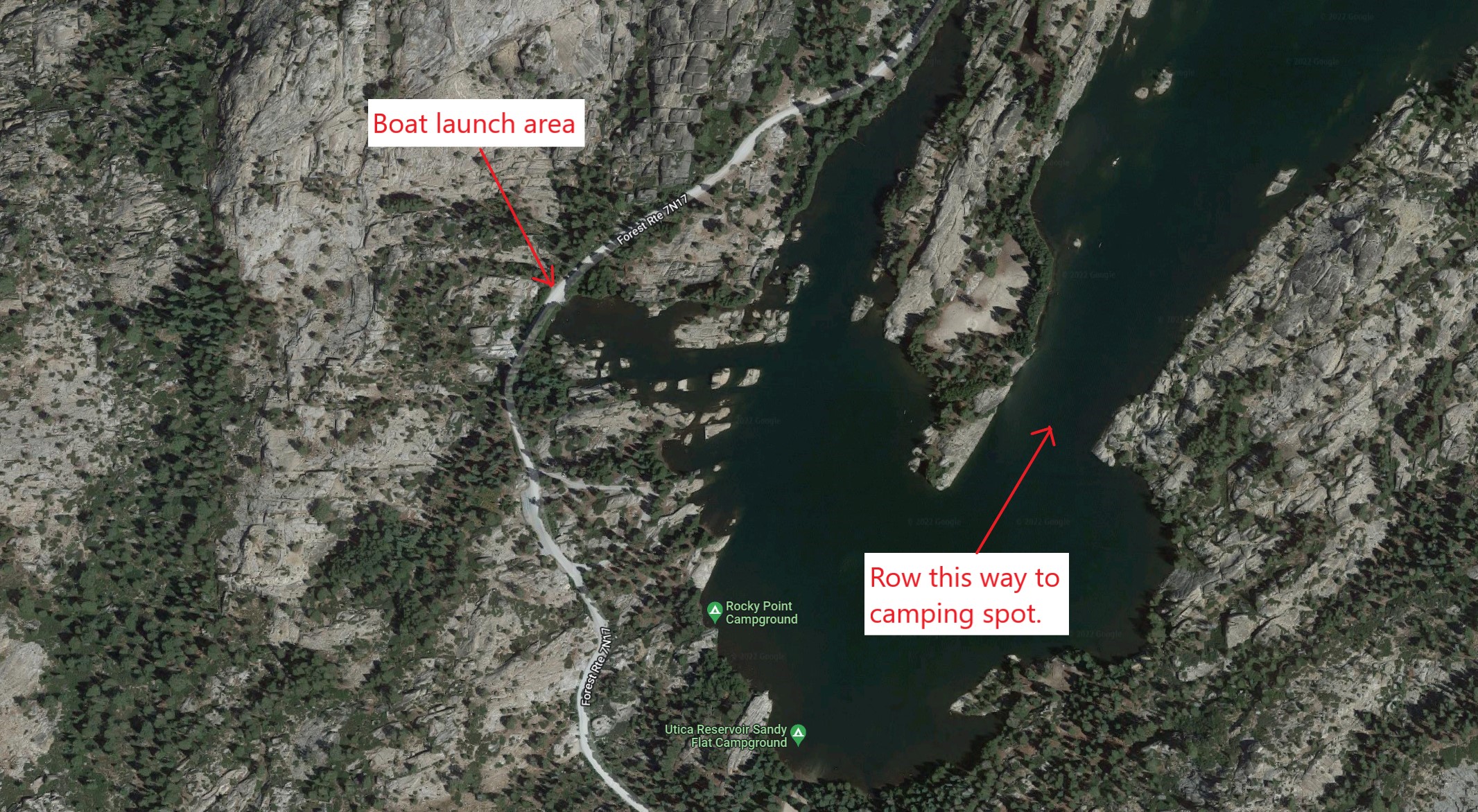
If you will be rowing, then the boat launch area will be the first stop. Inflate the boat here, load up the boat, then the hiking group can continue on to the parking spot.
Use the following Google Maps link to navigate to the boat launch area:
38°25'47.2"N 120°00'53.2"W
Following is a picture of the boat launch area and which way to row to camping spot:
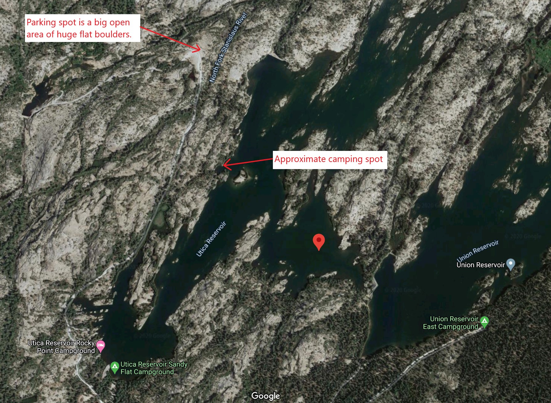
Parking Spot
Forest Route 7N17 ends at the top of an open area where there are huge flat boulders that we can park on. We then hike from the parking spot to our camping spot.
Use the following Google Maps link to navigate via the coordinates to the parking spot:
38°26'26.6"N 120°00'27.0"W
Picture showing the parking spot and camping spot:
Hiking to the Campsite
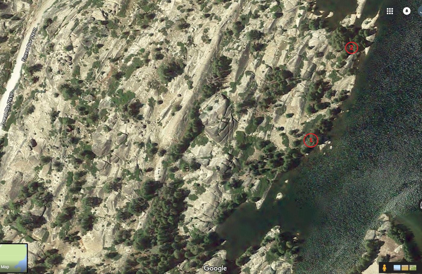
The reason we drive 4 hours to camp here is to be able to camp right next to the beautiful lake amongst the trees and boulders. We also have a couple favorite spots where people have already built a campfire ring from rocks and dragged a nice big log to sit on next to the fire. So, we try to get those spots, and if they're occupied we'll look for other ones.
There are no trails leading to our favorite camping spots, so each time we go we end up hiking a different route, climbing over boulders and figuring out the easiest way to cross the North Fork Stanislaus River.
If you're trying to meet up with us, either we can:
- Try to meet you at the parking spot and then take you to our camping spot. Hopefully walkie talkies are in range and we'd be able to communicate by then.
- OR If you take a direct route going East from the car, you'll hit the edge of the lake. Follow the edge of the lake heading South, and eventually you'll come across our campsite.
Camping Spots
Following is a picture of our favorite camping spots:
Lunch in Angels Camp
After leaving Utica Reservoir to head home, we can stop to eat lunch somewhere in Angels Camp: